Hancock County (Georgia) Cemeteries
Cemetery details
McCrary - Garner Family Cemetery

Location:
From the Hancock County Courthouse, go east on Broad St. for two blocks and turn right on Boland St. Follow Boland which becomes Linton Rd and go for 2.7 miles to Brown Chapel Rd on the left. Turn left on Brown Chapel and go 3.7 miles. The gravesite is behind a 2-story white house on the right.
From the Hancock County Courthouse, go east on Broad St. for two blocks and turn right on Boland St. Follow Boland which becomes Linton Rd and go for 2.7 miles to Brown Chapel Rd on the left. Turn left on Brown Chapel and go 3.7 miles. The gravesite is behind a 2-story white house on the right.
GPS coordinates: 33 11' 28" N 82 57' 26" W
or in degrees only form: 33.19111° N X 82.95722° W
See location on a Google map in a new window (NOTE:The map opens in a new window. The cemetery will be at the location indicated by a red marker.)
GMD: 118
Cemetery Status: Inactive
Predominant race: White
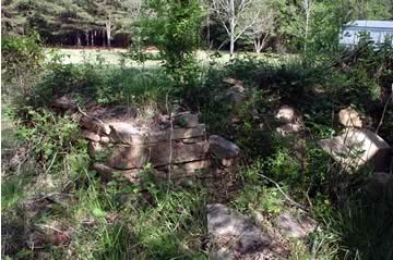
The original size of the foundation or wall appears to have been approximately 10 feet by 6 feet.
Indexer or Contributor: Glen Cook and Russell Poss
Unmarked Adult Grave - Louise Victoria McCrary Garner
Nov 4, 1856 - Jan 19, 1894
First w/o James Thomas Garner. Grave was a rock formation with a grave house on it. All info per Raymond Garner. No indication of identity on grave.
Grave 1