Hancock County (Georgia) Cemeteries
Cemetery details
Garner Family Cemetery #2 (tentative identification)

Location:
From the Hancock County Courthouse, go east on Hwy 15 for 1.5 miles. Turn right (south) on Cody Johnson Road. Go 3.8 miles. The cemetery will be in the woods, 316 feet to your left.
From the Hancock County Courthouse, go east on Hwy 15 for 1.5 miles. Turn right (south) on Cody Johnson Road. Go 3.8 miles. The cemetery will be in the woods, 316 feet to your left.
GPS coordinates: 33 12' 53.8" N 82 56' 10.3" W
or in degrees only form: 33.21494° N X 82.93619° W
See location on a Google map in a new window (NOTE:The map opens in a new window. The cemetery will be at the location indicated by a red marker.)
GMD: 113
Cemetery Status: Inactive
Predominant race: White
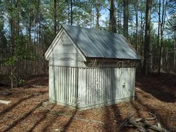
This cemetery is identifiable by its gravehouse, which covers a grave.
It is believed this cemetery is near the Chancey Garner homeplace, per J. E. Johnson, and so we have identified this cemetery as a Garner Cemetery.
Indexer or Contributor: Glen Cook
Unmarked Adult Grave - Miss or Mrs. Garner
A gravehouse. No identification on grave or gravehouse. All info per J. E. Johnson and Glen Cook.
Click for more info.
Click for more info.
Grave 1
Unmarked Graves
3 graves marked with brick formations.
Grave 2