Hancock County (Georgia) Cemeteries
Cemetery details
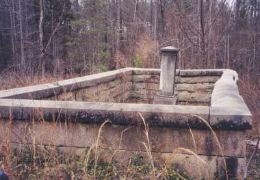
Gonder Family Cemetery

Location:
From the Hancock County Courthouse, go east on Hwy 16 for 4.7 miles. Turn left on the road to the Culverton Baptist Church. Go 0.5 mile to an intersection with stop sign. Go straight across intersection to dirt road (Fulsome Creek Rd) and go for 1.4 miles to a field road on the left. Turn onto the field road and go 0.2 mile. Gonder Cemetery is about 150 feet off the road on the right.
From the Hancock County Courthouse, go east on Hwy 16 for 4.7 miles. Turn left on the road to the Culverton Baptist Church. Go 0.5 mile to an intersection with stop sign. Go straight across intersection to dirt road (Fulsome Creek Rd) and go for 1.4 miles to a field road on the left. Turn onto the field road and go 0.2 mile. Gonder Cemetery is about 150 feet off the road on the right.
GPS coordinates: 33 19' 40.3" N 82 52' 15.3" W
or in degrees only form: 33.32786° N X 82.87092° W
See location on a Google map in a new window (NOTE:The map opens in a new window. The cemetery will be at the location indicated by a red marker.)
GMD: 111
Cemetery Status: Inactive
Predominant race: White
Indexer or Contributor: Brad Poole and Russell Poss
Elizabeth Gonder
- Apr 9, 1848
Aged 67 years. Inscription on opposite side of stone as Mark Gonder's.
Click for more info.
Click for more info.
Grave 2
Amazon N. Vinson
- May 21, 1939
Aged 24 years, 10 months, and 25 days. Consort of Gen. T. Vinson. Middle initial from footstone.
Click for more info.
Click for more info.
Grave 3
Unmarked Adult Slabs
Large slab outside the wall covering possibly 4 graves. Could be slave graves.
Grave 4