Hancock County (Georgia) Cemeteries
Cemetery details
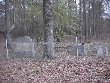
Hubert Family Cemetery

Location:
From the Hancock County Courthouse, go east on Hwy 22 for 7.5 miles to Springfield Church Rd. Turn left on Springfield Church Rd and go 3.4 miles to Springfield Church. As you face the church, the cemetery will be on the left side of the church, up in the woods, just off the highway.
From the Hancock County Courthouse, go east on Hwy 22 for 7.5 miles to Springfield Church Rd. Turn left on Springfield Church Rd and go 3.4 miles to Springfield Church. As you face the church, the cemetery will be on the left side of the church, up in the woods, just off the highway.
GPS coordinates: 33 24' 49.9" N 82 56' 36.5" W
or in degrees only form: 33.41386° N X 82.94347° W
See location on a Google map in a new window (NOTE:The map opens in a new window. The cemetery will be at the location indicated by a red marker.)
GMD: 107
Cemetery Status: Inactive
Predominant race: Black
The Hubert family established the successful Springfield school (a black grammar school) which prospered in the 1880s.
Indexer or Contributor: Jack and LaRue Johnson
Zack Hubert
1845 - 1926
"First Land Owners. Reared 12 children to Maturity. Great American Citizens." On same stone as and h/o Camilla Hillman.
Grave 1
Camilla Hillman Hubert
1858 - 1925
w/o Zack Hubert.
Grave 2
Unmarked Adult Slab - Zachary Hubert
1877 - 1958
All info per Bynes-Royal funeral home marker
Grave 3
Dr. Benjamin F. Hubert
1883 - Apr 29, 1958
He went about doing good. Dr & death date on original "Sellers" stone. Replacement stone has only 1958.
Click for more info.
Click for more info.
Grave 4
Jency Hubert Reeves
- Jan 5, 1958
Devoted teacher, inspired leader and loyal friend. "Mother" Has two gravestones - an older Sellers funeral home stone and a newer granite one.
Click for more info.
Click for more info.
Grave 5
Unmarked Graves
At least 8 more graves marked by fieldstones or depressions.
Grave 6