Hancock County (Georgia) Cemeteries
Cemetery details
James Thomas Family Cemetery
No marked graves found within this cemetery.

Location:
From the Hancock County Courthouse, go 2 blocks east on Broad Street to Boland St. Turn right on Boland, which becomes Linton Rd, and go 6.6 miles on Linton Road. Turn left off Linton Road onto Brown Chapel Rd. Go 0.3 mile to the first house (brick) on your right. Turn right, gain permission, and go past the left side of the house for 0.2 mile, following the field road which turns to the left. The cemetery will be to the left of the field road, with the granite walled area about 150 feet into the woods from the field road.
From the Hancock County Courthouse, go 2 blocks east on Broad Street to Boland St. Turn right on Boland, which becomes Linton Rd, and go 6.6 miles on Linton Road. Turn left off Linton Road onto Brown Chapel Rd. Go 0.3 mile to the first house (brick) on your right. Turn right, gain permission, and go past the left side of the house for 0.2 mile, following the field road which turns to the left. The cemetery will be to the left of the field road, with the granite walled area about 150 feet into the woods from the field road.
GPS coordinates: 33 10' 54.5" N 82 59' 43.9" W
or in degrees only form: 33.18181° N X 82.99553° W
See location on a Google map in a new window (NOTE:The map opens in a new window. The cemetery will be at the location indicated by a red marker.)
GMD: 118
Cemetery Status: Inactive
Predominant race: Both Black and White
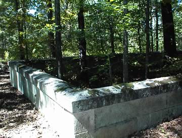
A 40' X 60' walled granite area sits within a much larger rectangular area designated by 3' granite posts at each corner. The larger area is approximately 200' by 250' and possibly has many unmarked graves. A few scattered fieldstones can be seen.
The name of this cemetery was from anecdotal accounts and the Kimbrough list. Confirming this as James Thomas' family cemetery is his will, which described the cemetery as bordered by 4 corner rocks and which asked that the cemetery and the stone wall enclosure be protected. It appears that he intended to erect tombs (gravestones) in the cemetery but probably died before it was accomplished.
Indexer or Contributor: Russell Poss, William Archer, and Susan Harrington
Unmarked Grave - James Thomas
ca. 1799 - 1866
Judge and lawyer
Grave 1
Unmarked Grave - Emmeline Gonder Thomas
Wife of James Thomas.
Grave 2
Unmarked Graves
Graves within walled granite block area, and many possible graves outside of walled area.
Grave 3