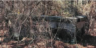
Hancock County (Georgia) Cemeteries
Cemetery details
Unnamed Cemetery #8 off Milton Reid Rd.

Location:
From the Hancock County Courthouse, go 2.6 miles northeast on Hwy 22 / Hwy 15 to where they split. Go right on Hwy 22 for 3.6 miles to Milton Reid Rd (County Road 17) (a dirt road) on the right (across from Smyrna Methodist Church). Turn right on Milton Reid Rd and go 2.2 miles. Turn right on a smaller woods road. Go 0.5 mile to a fork in the woods road. Bear left and go 0.3 mile to the walled cemetery on the right, approximately 50 feet off the road. The cemetery can be seen from the woods road.
From the Hancock County Courthouse, go 2.6 miles northeast on Hwy 22 / Hwy 15 to where they split. Go right on Hwy 22 for 3.6 miles to Milton Reid Rd (County Road 17) (a dirt road) on the right (across from Smyrna Methodist Church). Turn right on Milton Reid Rd and go 2.2 miles. Turn right on a smaller woods road. Go 0.5 mile to a fork in the woods road. Bear left and go 0.3 mile to the walled cemetery on the right, approximately 50 feet off the road. The cemetery can be seen from the woods road.
GPS coordinates: 33 20' 50" N 82 52' 50" W
or in degrees only form: 33.34722° N X 82.88056° W
See location on a Google map in a new window (NOTE:The map opens in a new window. The cemetery will be at the location indicated by a red marker.)
GMD: 111
Cemetery Status: Inactive
No marked graves. Only a granite wall approximately four (4) feet high and approximately twelve (12) feet long by twelve (12) feet wide.
Indexer or Contributor: Russell Poss
No marked graves.
Grave 1