Hancock County (Georgia) Cemeteries
Cemetery details
Unnamed Cemetery #16 at White Cedar Dr. near Lake Sinclair
on old Rives Plantation

Location:
From the Hancock County Courthouse, go southwest on Hwy 22 for 7.2 miles to the intersection of Hwy 22 and Main Street in Devereux. Turn right (at the backward fork) onto Main Street and go 0.2 mile until it dead ends into Jones Chapel Road. Turn left and follow Devereux / Jones Chapel Road for 4.9 miles to Carr Station Road. Turn right onto Carr Station Rd and go for 8.6 miles to Lake Sinclair Drive. Turn right and go 2.1 miles to White Cedar Dr. Turn left and go approximately 200 feet. Cemetery is on the right, inside a chain link fence.
From the Hancock County Courthouse, go southwest on Hwy 22 for 7.2 miles to the intersection of Hwy 22 and Main Street in Devereux. Turn right (at the backward fork) onto Main Street and go 0.2 mile until it dead ends into Jones Chapel Road. Turn left and follow Devereux / Jones Chapel Road for 4.9 miles to Carr Station Road. Turn right onto Carr Station Rd and go for 8.6 miles to Lake Sinclair Drive. Turn right and go 2.1 miles to White Cedar Dr. Turn left and go approximately 200 feet. Cemetery is on the right, inside a chain link fence.
GPS coordinates: 33 12' 42.4" N 83 11' 58.9" W
or in degrees only form: 33.21178° N X 83.19969° W
See location on a Google map in a new window (NOTE:The map opens in a new window. The cemetery will be at the location indicated by a red marker.)
GMD: 104
Cemetery Status: Inactive
The location was shown on a plat of Mr. Leonard Queen's property. The only evidence of graves were sunken areas. Other areas on the property indicate more graves. When a bank of the road along the side of a walled area was cut down, other graves were unearthed. Evidence of a blacksmith shop was found when the house was built on adjoining property.
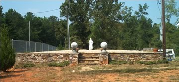
Cemetery has been rebuilt and no longer appears as how it was found. The entire area is 20 by 30 feet is covered with small stones and is surrounded by a 2 foot wall made of Tennessee field stone. A small statue of Jesus is at one end and steps leading up into the area are on the opposite end.
Indexer or Contributor: F. Dean and Mona L. Williams
Unmarked Adult Graves
Evidence of 15 graves.
Grave 1
Unmarked Child Graves
Evidence of 3 graves.
Grave 2