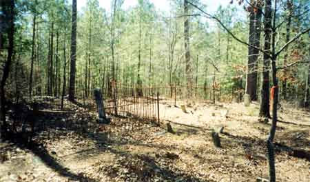
Bazemore/ Smith Cemetery
Location: Located off of Cyler Rd. on Hitichi National Forest. From Ocmulgee River Bridge on GA Hwy 18, travel approximately 1.6 miles on Jarrell Plantation Rd, turn left, go approximately 2.4 miles to Hitchiti Road, turn right, travel approximately 4.6 miles to foot travel road on left. Follow foot travel road approximately 200 yards to cemetery.

GPS coordinates in degrees only form: 33.06197° N X 83.65505° W
See location on a Google map in a new window (NOTE:The map opens in a new window. The cemetery will be at the location indicated by a red marker.)

Dist. 11 Land Lot 58
Date surveyed: July 4, 2001
Cemetery Status: Inactive
Predominant race: White

Other info: Many unmarked graves.

Indexer(s) or Contributor(s): Earl Colvin

List of Graves

Pers No.NameBirthDeathInscription and NotesService
1John P. Smith Sep 5, 1853Aug 20, 1895h/o Mattie Ross Married Jan. 31 1875
 
 
2    Unmarked adult grave
 
 
3    Unmarked graves
50 plus unmarked graves
 
 
4Infant Bazemore   d/o Mr. and Mrs. T.J. Bazemore
 
 
5Infant Bazemore   s/o Mr. and Mrs. T.J. Bazemore
 
 
6Elizabeth T. Bazemore Nov 8, 1845Nov 8, 1907w/o T.J. Bazemore
 
 
7T. J. Bazemore     Confederate States of America
Co. A 32nd Reg. Ga. Inf.


Please e-mail comments or questions to Susan J. Harrington at moreinfo@NOSPAM_FriendsofCems.org
(Remove "NOSPAM_" from the TO address in your email before sending.)

Return to Jones County Cemeteries home page