Hancock County (Georgia) Cemeteries
Cemetery details
McCown (John) grave

Location:
From the Hancock County Courthouse, go on Hwy 16 East for 9.0 miles to Perry Bell Rd. Turn left on Perry Bell Rd and travel 1.3 miles to Jewell Road. Turn left on Jewell Rd. and go 2.2 miles to Mayfield and the intersection with Union Church Rd. Turn right and go slightly less than 0.1 mile past the intersection with Union Church Road to a big two story house on your left next to the old store in Mayfield. The grave is located approximately 150' behind the two story house.
From the Hancock County Courthouse, go on Hwy 16 East for 9.0 miles to Perry Bell Rd. Turn left on Perry Bell Rd and travel 1.3 miles to Jewell Road. Turn left on Jewell Rd. and go 2.2 miles to Mayfield and the intersection with Union Church Rd. Turn right and go slightly less than 0.1 mile past the intersection with Union Church Road to a big two story house on your left next to the old store in Mayfield. The grave is located approximately 150' behind the two story house.
GPS coordinates: 33 21' 16.1" N 82 48' 10.1" W
or in degrees only form: 33.35447° N X 82.80281° W
See location on a Google map in a new window (NOTE:The map opens in a new window. The cemetery will be at the location indicated by a red marker.)
GMD: 112
Cemetery Status: Inactive
Predominant race: Black
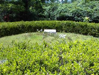
The grave is surrounded by a circular boxwood hedge.
Indexer or Contributor: Russell Poss