Hancock County (Georgia) Cemeteries
Cemetery details
Sanford Family Cemetery

Location:
From the Hancock County Courthouse, take Hwy 22 southwest for 7.2 miles to Devereux. Turn right (at backwards fork) onto Main Street. Go 0.2 mile to the dead end and turn left on Jones Chapel / Devereux Rd. Go 4.9 miles to where it dead ends into Carrs Station Road and turn right (west). Go about 3.7 miles to Lake Sinclair Drive and turn right. Go 3.9 miles on Lake Sinclair Drive to Island Creek Dr. on left. Turn left (south), and go 2.9 miles to Ridge Road. Turn right (west) and go 0.6 mile to the first gated woods road on the right after the road turns to dirt. The gate, which is typically locked, goes to a hunting club property. Go on foot approximately 0.4 mile down this path. There will be a sign on your right pointing toward the right. Go right and over the hill for approximately 200 yards or 0.1 mile to the tall oaks. Currently there is a deer stand over the cemetery.
From the Hancock County Courthouse, take Hwy 22 southwest for 7.2 miles to Devereux. Turn right (at backwards fork) onto Main Street. Go 0.2 mile to the dead end and turn left on Jones Chapel / Devereux Rd. Go 4.9 miles to where it dead ends into Carrs Station Road and turn right (west). Go about 3.7 miles to Lake Sinclair Drive and turn right. Go 3.9 miles on Lake Sinclair Drive to Island Creek Dr. on left. Turn left (south), and go 2.9 miles to Ridge Road. Turn right (west) and go 0.6 mile to the first gated woods road on the right after the road turns to dirt. The gate, which is typically locked, goes to a hunting club property. Go on foot approximately 0.4 mile down this path. There will be a sign on your right pointing toward the right. Go right and over the hill for approximately 200 yards or 0.1 mile to the tall oaks. Currently there is a deer stand over the cemetery.
GPS coordinates: 33 11' 02.1" N 83 13' 08.7" W
or in degrees only form: 33.18392° N X 83.21908° W
See location on a Google map in a new window (NOTE:The map opens in a new window. The cemetery will be at the location indicated by a red marker.)
GMD: 104
Cemetery Status: Inactive
Predominant race: White
Indexer or Contributor: Warren Layfield, Kathy Fuller, and Susan Harrington, Jewel Thompson
Jonnie Walker
- Oct 7, 1858
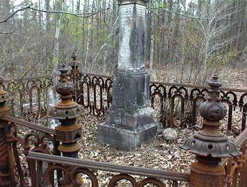
Aged 13 months. s/o Samuel and Ada Walker. "Our little Jonnie". Within iron fence.
Click for more info.
Click for more info.
Grave 3
Unmarked Grave - A. W.
A piece of marble outside fence.
Grave 4
Unmarked Grave - J. W.
A piece of marble outside fence.
Grave 5
Unmarked Graves
Four graves north of fenced enclosure.
Grave 6
Unmarked Graves
Four graves east of fenced enclosure.
Grave 7
Jeremiah Sanford
- Mar 20, 1838
d. in his 21st year. "Why should we mourn. Depating (sic) or shake at death's alarm. 'Tis but the voice that Jesus sends, To call us to His arms."
Click for more info.
Click for more info.
Grave 8
Jeremiah Sanford, Sr.
Sep 4, 1774 - Sep 2, 1843
An open Bible is carved upon his monument. Monument lies on its side on the ground.
Click for more info.
Click for more info.
Grave 9
Unmarked Graves
At least 5 more graves, 2 with fieldstones.
Grave 10