Location:
From the Baldwin County Courthouse, go east on Hancock St. and follow Highway 22 (Sparta Hwy) east for 2 miles. Turn left on Lake Laurel Road. Go 5.1 miles. Turn left on Gumm Cemetery Road. Go 1.8 miles to the power lines and 266 Gumm Cemetery Rd. On your right is a field road under the high power lines. Follow this road and cross the pasture to get to the cemetery. The cemetery is 0.4 mile down the power line easement and is past the intersection of more power lines coming in from the left. It is on the left side of the easement next to the woods.
GPS coordinates: 33 09' 53.9" N 83 09' 05.0" W
or in degrees only form: 33.16497° N X 83.15139° W
See location on a Google map in a new window (
NOTE:The map opens in a new window. The cemetery will be at the location indicated by a red marker.)
GMD: 116
Cemetery Status: Inactive
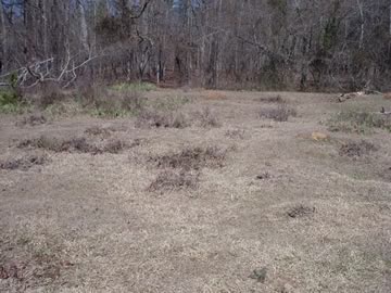
All that can be seen at this time are slight depressions in the field with some iris plant leaves. The depressions are visible because they have thistles bushes growing in them. There are no marked graves. Location of cemetery clearly shown on old plat maps.
This area was known as the Clara Walker Place in 1929. Prior to that it was a Thomas family property.
The cemetery is just over the border in Hancock County, but is reached through and is historically related to Baldwin County. A rock formation known as Thomas' site is slightly north of this cemetery.
This is the same cemetery as Unknown Cemetery #22 on Gumm Cemetery Road in the Hancock County Cemeteries website at http://friendsofcems.org/Hancock. Cemetery appears to be in Hancock County based on DOT and topographic maps.


