Memory Hill Cemetery
Cemetery Maps

Cemetery Maps
Types of Maps
There are 2 basic types of maps on this web site, as explained below:
(1) cemetery lot layout maps See Cemetery Section Map leading to lot layouts and
(2) cemetery grave location maps See Cemetery Section Map leading to grave locations.
1. Cemetery Lot Layout maps, created in 1998 and based on the city's cemetery map and a directory made in 1938, show the layout of lots or plots within the cemetery. The maps do not show actual graves. Within each side (east or west) are large sections, most often separated by driveways. These sections are lettered, starting with A, for the sections closest to the cemetery entrance and continuing southward and farther away from the main entrance. Within each section are lots, which range in size from 2 persons to 30 persons. Often those buried in the same lot are related to each other, although there are exceptions when a lot was subdivided and the sublot resold. Use these maps to find the Side, Section, and Lot of a grave found when using our search feature.
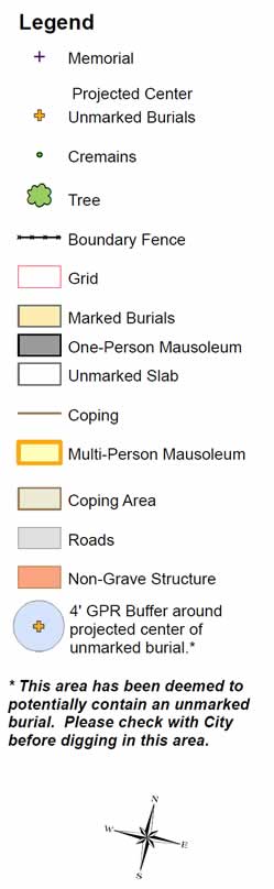
2. Cemetery Grave Location maps were developed from a cemetery survey and ground penetrating radar in 2012 and show marked and unmarked burials. These maps show individual graves, but not lot information. Because not all graves in a cemetery are marked, these maps can and should be used to protect unmarked burials when new graves are dug. They may also be useful if trying to find relatives who did not receive a grave marker or whose grave marker has disappeared. On these maps, only partial inscriptions on gravestones are shown. Also, due to time constraints, lighting, and the wear on gravestones, the map makers made many errors in transcription. A better reference for complete first, middle and last names and dates is found in the database search on this web site. Only use these grave maps for locating unmarked graves among your family members or for better understanding how your family members lie relative to each other.
The purpose of the survey was to locate unmarked graves found throughout the cemetery. Over 1200 unmarked graves were found. These graves are unmarked due to
Note: the red letters and lines are part of a grid system used by the map makers. The grid system does not correspond in any way to the Side, Section, Lot, and Person Number identification system used on this web site.
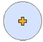
While Ground Penetrating Radar is not perfect at detecting graves, there is a high level of confidence (85-90%) that a blue circle on these maps indicates an unmarked grave. The yellow X in the center is the absolute center of the grave. Often rebar below ground can be found at this location when in the cemetery. The blue circle indicates a 4' buffer around the center.
Note that disturbing known graves, such as these, is a felony. Avoid digging in the area of an unmarked grave.
The cemetery survey and ground penetrating radar resulted in latitude and longitude coordinates of most graves. The web site links to Google maps to show the individual grave's location. Click here to see the Google map of the cemetery's llocation. (NOTE: The map opens in a new window. The cemetery will be at the location indicated by its GPS coordinates.)